

Inventory and map
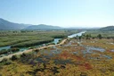
To identify wetland and buffer zones and to create an inventory and map of the living things in these areas.
Project · 2025
Although wetlands cover only about 2.5% of the Mediterranean Basin, they host more than one-third of all species.
Where?
What we do
To identify wetland and buffer zones and to create an inventory and map of the living things in these areas.
To identify the threats in and around wetlands and to work with local stakeholders on the necessary measures.
To raise awareness of the importance of the wetland ecosystem and of the balance between conservation and use.
To test the Green Light methodology.
To identify wetland and buffer zones and to create an inventory and map of the living things in these areas.
To identify the threats in and around wetlands and to work with local stakeholders on the necessary measures.
To raise awareness of the importance of the wetland ecosystem and of the balance between conservation and use.
To test the Green Light methodology.
By the end of this project, which will run until 31 December 2025, wetland areas suitable for restoration in Gökova are expected to be identified. In this way, with the agreement of local stakeholders and with due regard to the balance between conservation and use, the common vision and imagery of the area that emerge from the Green Light methodology can provide a basis for future projects. The aim of this programme is to compile an inventory, raise awareness and communicate with stakeholders.